Activity 2: Define Your Vulnerabilities and Risks to Future Shocks and Stressors
Purpose
In this activity, you will define your community’s vulnerability (based on current and projected exposure, sensitivity, and adaptive capacity) and the probability and potential magnitude of a hazard or stressor on your community.
Why?
To develop resilience strategies, it is essential to identify and assess the community’s vulnerability to current and future shocks and stressors as well as the likelihood and extent that they will impact your community.
When?
This will likely take between 1-3 months but will ultimately depend on the scope of your assessment and your approach to the assessment.
Tips
- Build on the work already happening in your community and region. You don’t have to reinvent the wheel! One asset for networking across government agencies and planning offices can be found through the Colorado Resiliency Office’s Peer Exchange program, which links local planners virtually.
- Integrate local knowledge. As you work on assessing vulnerability, local knowledge can be both a critical source of information as well as a key link to community support for your findings. Community feedback can also help reality check findings that may be based on generalized assumptions that do not apply in certain areas of the state.
- Think about “thresholds” when assessing vulnerability. Many systems operate well under a certain amount of stress and can withstand a certain degree of shock. However, once either stresses or shocks pass a certain intensity, or certain key aspects of the system are compromised, rapid failure of other parts of the system may follow. Try to identify when critical assets might be overwhelmed and what the consequences of that might mean for the community and other valued places, things, systems, and services.
How does my community do this?
- See what's out there. Assessing your vulnerabilities and your risks can be complex. If you require a deeper analysis, you can use tools like the US Climate Resilience Toolkit, the ICLEI Guide to Building Climate Resilience (pages 38-43), the Climate Ready Communities Guide to Building Climate Resilience (pages 55-82), or the FEMA Local Hazard Mitigation Planning Handbook (pages 5.1-5.20). You can also utilize the assess vulnerability template in the workbook.
- Inventory key community assets. It is important to begin this process by conducting an inventory of assets that are important to your community. What things, places, infrastructure, neighborhoods, parks, or community characteristics are important to your community? Inventory these through broad community engagement, expert input, background research, and conversations and synthesis among the core project team.
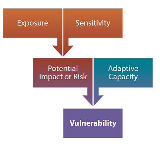
- Determine each asset’s exposure, sensitivity, adaptive capacity, and vulnerability to shocks and stressors. Once you have a list of assets, you will need to determine their exposure to shocks and stressors. Consider past, present, and potential future stressors - natural, climate change-related, social, demographic, economic, or otherwise – that may cause harm or create opportunities for your community. For a deep dive on the impacts of climate change on public health, learn more from the Colorado Health Institute’s Colorado’s Climate and Colorado’s Health Guide and Global Issue, Local Risk vulnerability index.
The relative vulnerability of key assets in your community depends on their exposure, sensitivity, and adaptive capacity. As you analyze and evaluate each of these characteristics of the assets and systems you will begin to get a clearer picture of your community’s overall vulnerability. These relative vulnerability rankings will provide you with the foundation to begin making choices about different resilience initiatives. Determining the relative vulnerability highlights which specific assets or parts of the community are most in need of immediate action to deal with future changes and can provide a more contextual description of how individual assets experience particular vulnerabilities. See the assess risk and risk matrix templates in the workbook. - Characterize your community’s risk. To characterize your community’s risk, you will need to consider the potential magnitude and probability of a potential hazard. This includes understanding how frequently an event has occurred in the past, and how climate change (or another driver) may change the frequency and severity of a hazard over time.

Community Call Out: Gunnison and Craig
In 2015, researchers working for the Colorado division of the Bureau of Land Management conducted a climate change vulnerability assessment focused on public land users and public land management. It took a three-tiered approach to data gathering that included: a systematic review of existing policies and practices within the agency’s planning resources that may change with response to climate stressors; a review of census data and public land use data using geospatial mapping and statistical analysis; and, in-depth case studies centered on two field offices located in Craig and Gunnison. Through numerous interviews, researchers identified some important dimensions of both general climate and weather vulnerability among public land-dependent communities. These results included specific aspects of land management that could exacerbate or ameliorate these risks, such as flexibility with cattle movement during drought. When compared with land use data, employment, and permitting statistics, it was possible to use insights from these case studies to select variables that highlighted parts of the state with elevated levels of dependence upon public land resources through direct and indirect economic and cultural links.
